United Kingdom

Discover the United Kingdom: A Tapestry of History, Royalty, and Natural Wonders

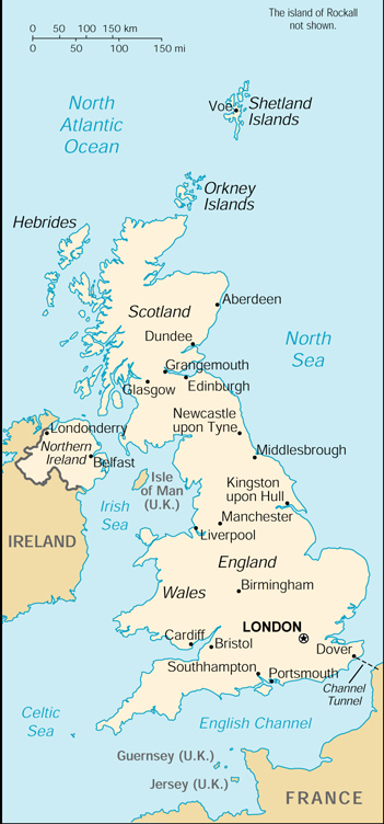
Embark on a journey to the United Kingdom, an archipelago where history and modernity intertwine in a rich tapestry that spans thousands of years. Located off the northwestern coast of mainland Europe, the UK is composed of England, Scotland, Wales, and Northern Ireland, each with its own unique heritage and allure. From the Neolithic Orkney to the Roman baths of Bath, the Norman conquest to the industrial revolution, the UK's legacy is as diverse as its landscapes.

Chronicles of the Isles: A Storied Past

The United Kingdom's narrative is marked by legendary monarchs, literary greats, and epoch-defining events. Its sovereignty has influenced global history, language, and culture, with a monarchy that continues to capture the world's imagination.

London: The Crown Jewel

In the heart of the UK, London stands as a global metropolis, boasting landmarks such as the Tower of London, Buckingham Palace, and the Houses of Parliament, alongside the modernity of the Shard and the cultural haven of the West End.

Edinburgh: A Capital of Culture

Travel north to Scotland's Edinburgh, where the iconic Edinburgh Castle looms over a city renowned for its festivals, arts, and the historic Royal Mile.

The Lake District: Nature's Masterpiece

England's Lake District offers tranquil beauty, with its idyllic lakes, mountainous landscapes, and literary associations with Wordsworth and Beatrix Potter.

The Giant's Causeway: Geological Splendor

In Northern Ireland, the Giant's Causeway showcases an awe-inspiring coastal landscape of basalt columns, born from volcanic fury and Irish legend.

From the rugged coasts of Cornwall to the sweeping valleys of Wales, and the picturesque glens of the Scottish Highlands, the United Kingdom invites exploration of its castles, cathedrals, and quaint villages. As you traverse through travel.frogsfolly.com, let us guide you through the UK's living history, its vibrant cultures, and its awe-inspiring natural beauty. Join us to discover the United Kingdom—a land where every stone tells a story and every landscape inspires a dream.

United Kingdom
Recent Uploads tagged unitedkingdom

			<p><a href="https://www.flickr.com/people/312_images/">312images</a> posted a photo:</p>
	
<p><a href="https://www.flickr.com/photos/312_images/55379445422/" title="G-SUNR Airbus A321-251NX of Jet2 | BHX 07/Jul/2026"><img src="https://live.staticflickr.com/65535/55379445422_2c52b17262_m.jpg" width="240" height="160" alt="G-SUNR Airbus A321-251NX of Jet2 | BHX 07/Jul/2026" /></a></p>

<p>2026_07_07_IMG_5783</p>
			<p><a href="https://www.flickr.com/people/204763567@N04/">notworththephoto</a> posted a photo:</p>
	
<p><a href="https://www.flickr.com/photos/204763567@N04/55380299276/" title="St Andrew&#039;s Church, Leyland, Lancashire"><img src="https://live.staticflickr.com/65535/55380299276_8bdf93f979_m.jpg" width="180" height="240" alt="St Andrew&#039;s Church, Leyland, Lancashire" /></a></p>

<p>St Andrew's Church stands on one of Leyland's oldest religious sites, with evidence of worship here dating back to at least the 12th century. The chancel dates from the 14th century, while the west tower was built in the late 15th or early 16th century. The church was rebuilt and restored several times during the 19th century and is now a Grade II* listed building.<br />
This photograph was taken on an overcast summer afternoon, with the dramatic sky adding contrast to one of Leyland's most recognisable landmarks.</p>
			<p><a href="https://www.flickr.com/people/petestuart/">The Rambling Tog</a> posted a photo:</p>
	
<p><a href="https://www.flickr.com/photos/petestuart/55380447079/" title="An ascent of Cross Fell on a cold snowy day in April"><img src="https://live.staticflickr.com/65535/55380447079_4f247ea3e1_m.jpg" width="240" height="160" alt="An ascent of Cross Fell on a cold snowy day in April" /></a></p>

<p>Cross Fell is the highest mountain in the Pennine Hills of Northern England and the highest point in England outside the Lake District</p>
			<p><a href="https://www.flickr.com/people/petestuart/">The Rambling Tog</a> posted a photo:</p>
	
<p><a href="https://www.flickr.com/photos/petestuart/55380265201/" title="An ascent of Cross Fell on a cold snowy day in April"><img src="https://live.staticflickr.com/65535/55380265201_089a84ff3a_m.jpg" width="240" height="160" alt="An ascent of Cross Fell on a cold snowy day in April" /></a></p>

<p>Cross Fell is the highest mountain in the Pennine Hills of Northern England and the highest point in England outside the Lake District</p>
			<p><a href="https://www.flickr.com/people/petestuart/">The Rambling Tog</a> posted a photo:</p>
	
<p><a href="https://www.flickr.com/photos/petestuart/55380437019/" title="An ascent of High Cup Nick along the Pennine Way from Dufton in Westmorland"><img src="https://live.staticflickr.com/65535/55380437019_144951746a_m.jpg" width="240" height="160" alt="An ascent of High Cup Nick along the Pennine Way from Dufton in Westmorland" /></a></p>

<p>High Cup Gill (or High Cup Nick or just High Cup), almost a geometrically perfect U-shaped chasm, is a valley deeply incised into the Pennine scarp</p>
			<p><a href="https://www.flickr.com/people/petestuart/">The Rambling Tog</a> posted a photo:</p>
	
<p><a href="https://www.flickr.com/photos/petestuart/55380250101/" title="An ascent of High Cup Nick along the Pennine Way from Dufton in Westmorland"><img src="https://live.staticflickr.com/65535/55380250101_1960eb25d7_m.jpg" width="240" height="160" alt="An ascent of High Cup Nick along the Pennine Way from Dufton in Westmorland" /></a></p>

<p>High Cup Gill (or High Cup Nick or just High Cup), almost a geometrically perfect U-shaped chasm, is a valley deeply incised into the Pennine scarp</p>
			<p><a href="https://www.flickr.com/people/40172673@N03/">Southsea_Matt</a> posted a photo:</p>
	
<p><a href="https://www.flickr.com/photos/40172673@N03/55380358798/" title="450109 &amp; 450007, Portsmouth &amp; Southsea, October 9th 2023"><img src="https://live.staticflickr.com/65535/55380358798_cde4de288d_m.jpg" width="240" height="160" alt="450109 &amp; 450007, Portsmouth &amp; Southsea, October 9th 2023" /></a></p>

<p>1P46 1345 Portsmouth Harbour-London Waterloo.</p>
			<p><a href="https://www.flickr.com/people/petestuart/">The Rambling Tog</a> posted a photo:</p>
	
<p><a href="https://www.flickr.com/photos/petestuart/55380644895/" title="An ascent of High Cup Nick along the Pennine Way from Dufton in Westmorland"><img src="https://live.staticflickr.com/65535/55380644895_ac93537a7d_m.jpg" width="240" height="160" alt="An ascent of High Cup Nick along the Pennine Way from Dufton in Westmorland" /></a></p>

<p>High Cup Gill (or High Cup Nick or just High Cup), almost a geometrically perfect U-shaped chasm, is a valley deeply incised into the Pennine scarp</p>
			<p><a href="https://www.flickr.com/people/richardmgn/">rm tourist photos</a> posted a photo:</p>
	
<p><a href="https://www.flickr.com/photos/richardmgn/55380235996/" title="DSC_7706-1 21 juni 2026 12.51"><img src="https://live.staticflickr.com/65535/55380235996_2f5956cbca_m.jpg" width="240" height="135" alt="DSC_7706-1 21 juni 2026 12.51" /></a></p>

<p>Looking back toward Carnedd Daffyd (1 044 m) in center from Cefn Ysgolion Duon, Snowdonia/Eryri, Wales</p>
			<p><a href="https://www.flickr.com/people/petestuart/">The Rambling Tog</a> posted a photo:</p>
	
<p><a href="https://www.flickr.com/photos/petestuart/55380390424/" title="Hiking on the Dales High Way between Newbiggin on Lune and Appelby in westmorland"><img src="https://live.staticflickr.com/65535/55380390424_c4670d1498_m.jpg" width="240" height="160" alt="Hiking on the Dales High Way between Newbiggin on Lune and Appelby in westmorland" /></a></p>

<p>Ravenstonedale is an unspoiled picturesque moor lying at the foot of the Howgills in Cumbria. Nearby is the village of Newbiggin-on-Lune. Kirkby Stephen is about 4 miles north east.</p>
			<p><a href="https://www.flickr.com/people/petestuart/">The Rambling Tog</a> posted a photo:</p>
	
<p><a href="https://www.flickr.com/photos/petestuart/55380389494/" title="Vintage tractor  on the Dales High Way between Newbiggin on Lune and Appelby in westmorland"><img src="https://live.staticflickr.com/65535/55380389494_8a1d6c4d59_m.jpg" width="240" height="160" alt="Vintage tractor  on the Dales High Way between Newbiggin on Lune and Appelby in westmorland" /></a></p>

<p>02.04.2022 Great Asby, Cumbria, UK. Rusting orange vintage tractor on farmland on the Dalles High Way near to Appelby in Cumbria</p>
			<p><a href="https://www.flickr.com/people/petestuart/">The Rambling Tog</a> posted a photo:</p>
	
<p><a href="https://www.flickr.com/photos/petestuart/55380205831/" title="Truck on the Dales High Way between Newbiggin on Lune and Appelby in westmorland"><img src="https://live.staticflickr.com/65535/55380205831_350070662b_m.jpg" width="240" height="160" alt="Truck on the Dales High Way between Newbiggin on Lune and Appelby in westmorland" /></a></p>

<p>02.04.2022 Rutter Mill, Appelby, Cumbria, UK. Dump truck parked and blocking the Dales High way near the village of Hoff in Cumbria</p>
			<p><a href="https://www.flickr.com/people/petestuart/">The Rambling Tog</a> posted a photo:</p>
	
<p><a href="https://www.flickr.com/photos/petestuart/55380210626/" title="Sheep on the Dales High Way between Newbiggin on Lune and Appelby in westmorland"><img src="https://live.staticflickr.com/65535/55380210626_de6c292881_m.jpg" width="240" height="160" alt="Sheep on the Dales High Way between Newbiggin on Lune and Appelby in westmorland" /></a></p>

<p>Ravenstonedale is an unspoiled picturesque moor lying at the foot of the Howgills in Cumbria. Nearby is the village of Newbiggin-on-Lune. Kirkby Stephen is about 4 miles north east.</p>
			<p><a href="https://www.flickr.com/people/petestuart/">The Rambling Tog</a> posted a photo:</p>
	
<p><a href="https://www.flickr.com/photos/petestuart/55380317638/" title="The Eden Viaducts and Poetry Walk beyween Nateby and Kirkby Stephen in Cumbria"><img src="https://live.staticflickr.com/65535/55380317638_f4c89f55e2_m.jpg" width="240" height="160" alt="The Eden Viaducts and Poetry Walk beyween Nateby and Kirkby Stephen in Cumbria" /></a></p>

<p>01.04.2022 Kirkby stephen, Cumbria, Uk. Cottages on the river Eden near to Kirkby Stephen in Cumbria</p>
			<p><a href="https://www.flickr.com/people/petestuart/">The Rambling Tog</a> posted a photo:</p>
	
<p><a href="https://www.flickr.com/photos/petestuart/55380589255/" title="Camping pod with green door at Pennine View campsite in Kirkby Stephen"><img src="https://live.staticflickr.com/65535/55380589255_c95a5b5e61_m.jpg" width="240" height="160" alt="Camping pod with green door at Pennine View campsite in Kirkby Stephen" /></a></p>

<p>01.04.2022 Kirkby stephen, Cumbria, Uk. A camping pod holiday offers a cosy retreat, adding a sprinkle of comfort to your time away. Leave that old tent to gather cobwebs</p>
			<p><a href="https://www.flickr.com/people/petestuart/">The Rambling Tog</a> posted a photo:</p>
	
<p><a href="https://www.flickr.com/photos/petestuart/55379255182/" title="The River Eden near to Nateby above kirkby Stephen in Cumbria"><img src="https://live.staticflickr.com/65535/55379255182_c9686beefd_m.jpg" width="240" height="160" alt="The River Eden near to Nateby above kirkby Stephen in Cumbria" /></a></p>

<p>Stenkrith Bridge, just outside Kirkby Stephen on the road to Nateby, is actually a combination of several bridges where the Eden both bends and falls</p>
			<p><a href="https://www.flickr.com/people/petestuart/">The Rambling Tog</a> posted a photo:</p>
	
<p><a href="https://www.flickr.com/photos/petestuart/55380552790/" title="Walking at Loch Freuchie circuit at Amulree and the Rob Roy Way"><img src="https://live.staticflickr.com/65535/55380552790_269e01d85c_m.jpg" width="240" height="160" alt="Walking at Loch Freuchie circuit at Amulree and the Rob Roy Way" /></a></p>

<p>25.03.2022 Amulree, Perthshire, Scotland, UK.  Disused barn on the Rob Roy Way near to Amulree in Perthshire</p>
			<p><a href="https://www.flickr.com/people/petestuart/">The Rambling Tog</a> posted a photo:</p>
	
<p><a href="https://www.flickr.com/photos/petestuart/55380282083/" title="Loch Tay is a freshwater loch in the central highlands of Scotland, in the Perth and Kinross"><img src="https://live.staticflickr.com/65535/55380282083_1004833fc3_m.jpg" width="240" height="160" alt="Loch Tay is a freshwater loch in the central highlands of Scotland, in the Perth and Kinross" /></a></p>

<p>Loch Tay is a magnificent dark stretch of water, 15 miles (24 km) long and around 508 ft deep. It’s the largest loch in Perthshire and one of the deepest in Scotland.</p>
			<p><a href="https://www.flickr.com/people/petestuart/">The Rambling Tog</a> posted a photo:</p>
	
<p><a href="https://www.flickr.com/photos/petestuart/55379239572/" title="The Pass of Killiecrankie is an impressive wooded gorge, which is a popular beauty spot"><img src="https://live.staticflickr.com/65535/55379239572_3e83afe3a5_m.jpg" width="240" height="160" alt="The Pass of Killiecrankie is an impressive wooded gorge, which is a popular beauty spot" /></a></p>

<p>20.03.2022 Kiliecrankie, Perthshire, Scotland, UK. Three miles north of Pitlochry by the A9 road, the Pass of Killiecrankie, is a gorge lying between Ben Vrackie and Tenandry Hill</p>
			<p><a href="https://www.flickr.com/people/petestuart/">The Rambling Tog</a> posted a photo:</p>
	
<p><a href="https://www.flickr.com/photos/petestuart/55380338234/" title="Walking at Loch Freuchie circuit at Amulree and the Rob Roy Way"><img src="https://live.staticflickr.com/65535/55380338234_a0bbb8c50b_m.jpg" width="240" height="160" alt="Walking at Loch Freuchie circuit at Amulree and the Rob Roy Way" /></a></p>

<p>Stile over a fence on the Rob Roy way near to Amulree in Perthshire</p>
Sign On